Wheel Fun : Pedaling Pine Hill Community Forest's Trails
Read this article in the September 1, 2023 edition of the Conway Daily Sun by clicking HERE
Conway, NH - Curious about the recent Pine Hill Community Forest trail building, I contacted Upper Saco Valley Land Trust’s Executive Director Jennifer Pribble and Land Steward Greg Bjork to find out how it was going. They put me in touch with Mike Morin, USVLT conservation director. He invited me to ride both the USVLT’s Redstone Preserve and Pine Hill trails with him and Outreach Coordinator Carissa Milliman. I invited Jeanne Twehous to join us.
We met at Hemlock Lane. Mike’s ride plan was a Redstone and Pine Hill link up. Starting with Redstone, we rode along “Swenson’s” and up “Cheater.” I didn’t know most of “Cheater” and the quarry trails are within USVLT’s boundary. USVLT plans to manage these trails to make sure they’re safe and sustainable. On our way out, we checked out Conway Public Library’s new interpretive signs.
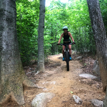
Before the train tracks, we turned left on the road that goes behind Walmart and ends at Route 302. Negotiating a tricky road crossing, we picked up the old Rec Path trail. Riding straight through recent clearcutting, we came out at Eagle’s Way almost across from the new parking lot. We crossed over, found the Summit Trail (1.1 miles uphill, biking only section) to the right of lot and started climbing. Steep switchbacks brought us to the Corridor 19 snowmobile junction. We kept climbing past cairns, a water tower and rock ledge until we reached Pine Hill’s summit (883’). Then the downhill fun began.
The Summit (1.3 miles downhill biking only section) has lots of berms, turns and optional features —a payoff for all the climbing. In no time, we were at the bottom, coming out on a logging road. A future .7-mile Eagle’s Way connector trail here will take riders and hikers quickly back to the new parking lot.
We continued riding straight to the power line. At the Rec Path junction, if we turned right, we’d connect to the Saco River. A left turn goes directly to Kennett High School. Instead, we continued straight, then swung left toward the Gary Millen Stadium football field. Turning right on the Ravine Trail, we crossed the bridge, rode around playing fields and then took a single track that veered off right. We arrived back at the powerline and the clear-cut and took the trail back to Route 302.
Once safely across, we took a dirt road back to the railroad crossing, skirted Walmart’s parking lot and found a cut-through back to Hemlock. The total trip was 7.75 miles, neatly connecting two USVLT land parcels and trail systems.
Other options exist for connectivity. Old Spokes once made a big loop by connecting Pine Hill and Redstone via the old Bike for Books’ route through Redstone. We crossed East Conway Road and rode behind the police station to Smith-Eastman Park. Picking up the rec path, we pedaled under the Route 302 bridge, then took a connector back to high school. At Eagle’s Way, we took the road back to the parking lot. It was an interesting multi-surface ride.
Riders could also use the new rec path to connect quickly from Cranmore to Hemlock and then to Pine Hill and back to make an Eastside sampler. Invent your own connections.
Where is Pine Hill and what’s happening there?
The 594-acre Pine Hill Community Forest is in the middle of North Conway’s commercial district, bounded west by Route 16, south by Saco River and north and east by Route 302. However, many people don’t recognize the name. Pine Hill (elevation 883’) is shown on maps, but few are familiar with the area around it, except for Kennett High School and Mineral Spring building. It’s hidden in plain sight.
That’s already changing. In 2018, the Upper Saco Valley Land Trust acquired 460 acres from the Kennett Company and added 134 acres in 2022, thus creating the Pine Hill Community Forest. A Pine Hill Management Committee was formed to decide how to use this property responsibly. In line with USVLT’s mission of “preserving land for community benefit,” they brought together Tin Mountain Conservation Center, Kennett High School and the Conway School District, Mount Washington Valley Trails Association and the Conway Rec Path Committee, Mountain Meadows Snowmobile Club and the Town of Conway to construct a strategic plan for this new community forest.
In 2021, one of the first Pine Hill projects was completed — the 1.2-mile Ravine Trail and Ravine connector trail. This multi-use trail gives access to the KHS softball and baseball fields and connects existing trails and forest roads, finishing north of the hockey field and connecting to Eagle’s Way. It’s a great trail, designed and built by Matt Coughlan of Recon Trail Design LLC. Coughlan and his crew last year also improved the Conway Rec Path’s trail surface from the high school to the Saco. Now, that trail is easier to run, bike, ski or snowshoe.
The latest trail project is a multi-use and mountain bike trail on Pine Hill. Coughlan did the layout and design for both the uphill and downhill sections of the 2.4-mile Summit Trail. Combined with the .7-mile Eagle’s Way connector trail, it will form a 3-mile loop suitable for KHS mountain bike team competitions and recreational use by walkers, runners and bikers. The trails are a compilation of efforts by many different organizations. Construction of the uphill-only biking trail was started in the spring of 2022 by White Mountain New England Mountain Bike Association volunteers Rob Adair with his excavator and Mike Simoneau with his tools. WMNEMBA also used a $8,500 NEMBA Signature Grant to support USVLT’s Pine Hill project. NEMBA volunteer work sessions finished the 1.1-mile two-way hiking/uphill biking-only trail to Pine Hill’s summit in June. Coughlan and crew constructed the 1.3-mile downhill biking-only portion of the Summit Trail this summer. It has wide berms, turns and optional features to try. It’s smooth, flowy, fast and lots of fun to ride. After a quick descent, it dumps you out onto a logging road. Continuing straight brings you to the powerline behind the high school. From there, possible connections can be made to the rec path, Kennett High and the Ravine Trail.
This spring, a new parking lot was constructed a half-mile up Eagle’s Way on the right by Shane Gurney from Gurney Land Care. This lot gives direct access to the completed Summit Bike Uphill-only section. Look for the newly installed sign on the right. A kiosk will be installed there sometime this fall. On the left will be the .7-mile Eagle’s Way connector trail, which is yet to be completed. A sign warns: “Trail closed for construction.” It will be a two-way hiking/biking shortcut to get back to the parking area without going around the Ravine Trail. USVLT volunteers have been working hard on it this summer, with AmeriCorps volunteers’ benching and stump-pulling help. KHS mountain bike team members will continue the work this fall. Bjork shared the “Eagle's Way connector is a work in progress and likely won't be fully operational this year though we hope to have a roughed-in version passable this fall.” If you’d like to volunteer to help finish this trail, send an email to info@usvlt.org.
To add more miles, pedal the Ravine Trail back to its terminus with Eagle’s Way, making a connection to the parking lot where you started. Lots of connections and loops are possible. For maps to plan your ride link-ups, check these out: 1. To see the Pine Hill map, go to Pine Hill Map. The Summit Trail is also listed now on Trailforks - Summit Trail. 2. The Eastside trails map can be seen by going to https://www.wmnembachapter.org/maps. Scroll down to “Eastside map,” which includes the Redstone trails.
Sally McMurdo is a bike safety instructor and cyclist who lives in Conway.